


You may also like
-
Ancient map of Paris Poster
Friedrich Arnold Brockhaus · 1894 · Detailed Paris city map vintage print with blue Seine and red boundaries
Poster from 69 kr · Framed from 122,67 kr
Regular price From 46,00 krRegular price -
Ancient map of London Poster
Friedrich Arnold Brockhaus · 1899 · Detailed London map poster tracing the Thames and street grid in muted tones
Poster from 69 kr · Framed from 122,67 kr
Regular price From 46,00 krRegular price -
Ancient map of Rome Poster
Friedrich Arnold Brockhaus · 1883 · Detailed Rome map vintage print tracing the Tiber with crisp labeled districts
Poster from 69 kr · Framed from 122,67 kr
Regular price From 46,00 krRegular price -
Planiglobes of the Earth I Poster
Institute of Liepzig · 1860 · Detailed hemispheric world map vintage print with crisp graticules and antique typography
Poster from 69 kr · Framed from 122,67 kr
Regular price From 46,00 krRegular price


-

"Very nice Posters. The quality is amazing and we received it very quickly !"
-

"A shop to visit absolutely. Huge selection of posters. We spent more than an hour there !"
-

"Perfect to find gift. Price are very good. An they can frame and pack it on site"


About the Artist
Friedrich Arnold Brockhaus was a German publisher whose legacy is deeply tied to the world of encyclopedias and reference works. While Brockhaus himself lived in the early nineteenth century, his name continued to represent scholarly excellence through the Leipzig-based publishing house that bore it. The Brockhaus imprint became synonymous with accuracy, education, and the dissemination of knowledge across generations.
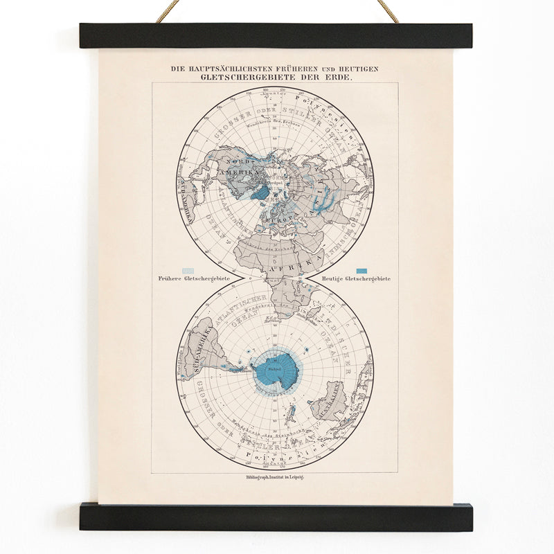
This polar regions map reflects the enduring mission of Brockhaus publications: to make complex information accessible and visually engaging. It belongs to a tradition of vintage map wall art that bridges scientific progress and public curiosity.
The Artwork
Created in 1897, this map emerged during a period of intense interest in the Earth's poles, fueled by new expeditions and scientific debates. At the turn of the century, the Arctic and Antarctic were seen as the last great unknowns, and maps like this distilled the latest discoveries into a form that could educate and inspire. Such plates were essential tools in schools and libraries, symbolizing the era's faith in exploration and rational understanding of the world.
By depicting the polar regions with precision, the artwork marks a shift from myth to measured knowledge, capturing the spirit of late nineteenth-century cartography and its optimism about human progress.
Style & Characteristics
This map exemplifies classic atlas design, featuring crisp black lines, careful labeling, and a balanced grid structure. The composition separates land, sea, and ice with subtle tonal differences, lending the sheet a sense of clarity and calm. Cool blue seas contrast elegantly with the warm, aged paper, while deep blacks define coastlines and boundaries.
The overall effect is both archival and contemporary, inviting close study and appreciation of detail. Its contemplative, analytical mood makes it especially appealing to admirers of scientific posters and those who value the aesthetics of information design.
In Interior Design
This vintage print is ideal for a study, home office, or reading nook, where its detailed imagery can be explored at leisure. It complements modern, Scandinavian, and classic interiors, adding a thoughtful, intellectual touch without overwhelming the space.
Pair with natural wood or black frames, and echo its palette with beige textiles or blue ceramic accents. For a cohesive look, combine it with other beige toned wall decor or nautical-inspired pieces.