


You may also like
-
Stedregister over de britiske øer Plakat
John Bartholomew · 1887 · Detaljeret vintage tryk af de britiske øer med klare stednavne og atlasagtigt layout
Plakat fra 69 kr · Indrammet fra 122,67 kr
Normalpris Fra 46,00 krNormalpris -
Gammelt kort over London Plakat
Friedrich Arnold Brockhaus · 1899 · Detaljeret London kortplakat der følger Themsen og gadenettet i afdæmpede toner
Plakat fra 69 kr · Indrammet fra 122,67 kr
Normalpris Fra 46,00 krNormalpris -
Kort over Island Plakat
Kongelige Danske Søkortarkiv · 1871 · Detaljeret nautisk vintagetryk der viser Island med dybdemålinger og kystnavne
Plakat fra 69 kr · Indrammet fra 122,67 kr
Normalpris Fra 46,00 krNormalpris -
Antikt kort over Spanien Plakat
Carl Diercke · 1905 · Detaljeret vintagetryk af Den iberiske halvø med regionale grænser og bløde beige og blå farver
Plakat fra 69 kr · Indrammet fra 122,67 kr
Normalpris Fra 46,00 krNormalpris


-

"Very nice Posters. The quality is amazing and we received it very quickly !"
-

"A shop to visit absolutely. Huge selection of posters. We spent more than an hour there !"
-

"Perfect to find gift. Price are very good. An they can frame and pack it on site"


Om kunstneren
Universal Atlas of the World er resultatet af en kollektiv tradition inden for atlasproduktion omkring århundredskiftet snarere end én enkelt kunstner. Sådanne værker samlede korttegnere, gravører og redaktører for at skabe omfattende opslagsværker til skoler, biblioteker og hjem. Omkring 1900 blev kort værdsat for deres evne til at gøre geografi tilgængelig og visuelt engagerende i en tid, hvor viden om verden blev betragtet som vigtig almenkundskab.
Disse vintage kortplakater repræsenterer periodens fokus på nøjagtighed og klarhed og fungerede både som praktiske redskaber og som diskrete prestigeobjekter på væggen.
Værket
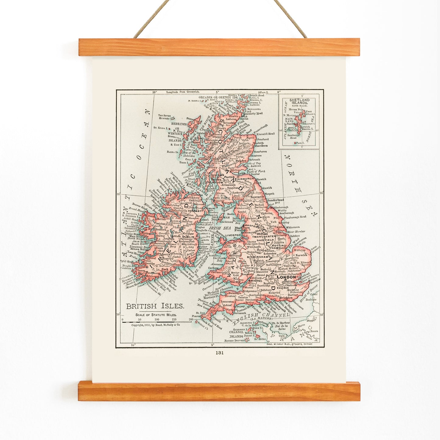
Dette kort fra 1900 over de britiske øer blev til i en periode, hvor kartografi havde stor betydning for, hvordan afstande, grænser og national identitet blev opfattet. I edwardiansk tid var kort uundværlige i undervisning og rejse, fordi de hjalp læseren med at forestille sig forholdet mellem England, Skotland, Wales og Irland og de tilstødende farvande.
Oprindeligt udgivet som del af et atlas gav dette ark et klart overblik til sammenligning af regioner og til forståelse af øernes indbyrdes forbindelser. I dag fungerer det som kartografisk vægkunst, et historisk øjebliksbillede af en gruppe øer defineret af søveje og fælles historier.
Stil og karakteristika
Designet centrerer sig om de britiske øers karakteristiske silhuet, placeret i generøse margener der minder om opslagsværkets plader. Fine sorte stregtegninger afgrænser kystlinjer og interne grænser, mens tidsbestemt typografi giver stednavnene en arkivagtig autoritet.
Kortet er trykt på varm beige papir med klare sorte detaljer og diskrete røde fremhævninger, som guider øjet uden at dominere kompositionen. Helhedsindtrykket er akademisk og afdæmpet, og det fremkalder atmosfæren fra edwardianske tryk.
I indretningen
Dette kortkunsttryk over de britiske øer passer godt i arbejdsværelset, gangen eller stuen, hvor et roligt og reflekteret blikfang ønskes. Det supplerer både klassiske indretninger og moderne rum, der leger med mødet mellem historisk og nutidig stil, samt vægopsætninger med rejse- eller arvestemning.
Giv det en ramme i egetræ, valnød eller sort, og koordiner med beige vægkunst for et harmonisk udtryk. For at fremhæve de røde accenter kan du tilføje en pude eller et tæppe i matchende nuance, eller samle flere klassiske kunsttryk for et samlet, tidløst udtryk.